


Mayo Elementary Voting District, Spartanburg County, South Carolina
About
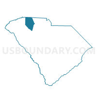
Outline

Summary
| Unique Area Identifier | 666703 |
| Name | Mayo Elementary Voting District |
| County | Spartanburg County |
| State | South Carolina |
| Area (square miles) | 12.40 |
| Land Area (square miles) | 12.12 |
| Water Area (square miles) | 0.28 |
| % of Land Area | 97.74 |
| % of Water Area | 2.26 |
| Latitude of the Internal Point | 35.08530420 |
| Longtitude of the Internal Point | -81.84997090 |
Maps


Graphs
Select a template below for downloading or customizing gragh for Mayo Elementary Voting District, Spartanburg County, South Carolina


Neighbors
Neighoring Voting District (by Name) Neighboring Voting District on the Map
- Carlisle Fosters Home Voting District, Spartanburg County, SC
- Cherokee Springs Fire Station Voting District, Spartanburg County, SC
- Chesnee Senior Center Voting District, Spartanburg County, SC
- Cowpens Fire Station Voting District, Spartanburg County, SC
- Ezells-Butler Voting District, Cherokee County, SC
Top 10 Neighboring County Subdivision (by Population) Neighboring County Subdivision on the Map
- Boiling Springs CCD, Spartanburg County, SC (23,368)
- Macedonia CCD, Cherokee County, SC (7,713)
- Chesnee CCD, Spartanburg County, SC (6,382)
- Mayo CCD, Spartanburg County, SC (5,310)
Top 10 Neighboring Place (by Population) Neighboring Place on the Map
Top 10 Neighboring Unified School District (by Population) Neighboring Unified School District on the Map
- Spartanburg School District 2, SC (58,308)
- Cherokee County School District, SC (53,383)
- Spartanburg School District 3, SC (16,629)
Top 10 Neighboring State Legislative District Lower Chamber (by Population) Neighboring State Legislative District Lower Chamber on the Map
- State House District 38, SC (37,612)
- State House District 30, SC (34,013)
- State House District 33, SC (32,160)
- State House District 32, SC (31,424)
Top 10 Neighboring State Legislative District Upper Chamber (by Population) Neighboring State Legislative District Upper Chamber on the Map
- State Senate District 11, SC (101,438)
- State Senate District 14, SC (98,937)
- State Senate District 13, SC (92,248)
Top 10 Neighboring 111th Congressional District (by Population) Neighboring 111th Congressional District on the Map
Top 10 Neighboring Census Tract (by Population) Neighboring Census Tract on the Map
- Census Tract 224.03, Spartanburg County, SC (7,920)
- Census Tract 9701, Cherokee County, SC (7,713)
- Census Tract 223.02, Spartanburg County, SC (5,310)
- Census Tract 223.04, Spartanburg County, SC (4,433)